About
The Panodata Map Panel is a map panel for Grafana with improved convenience, robustness, features and under active development.
It builds upon the original Grafana Worldmap Panel, integrates different contributions coming from the community and continues adding dearly requested features while focusing on robustness and stability.
Features
-
Clickthrough links
This combines both clickthrough link implementations #129 and #190, integrates sticky labels from6ac68efand adds basic variable interpolation based on keys fromdataPoint. -
Improve editor screen layout and dialogs
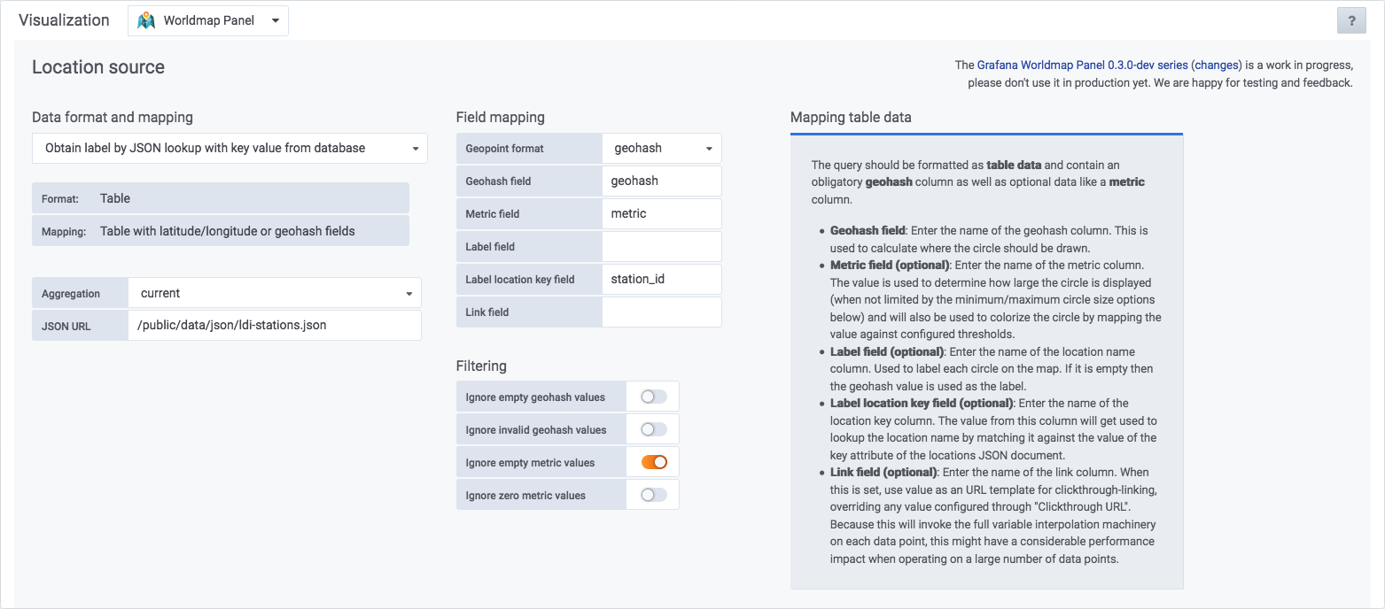
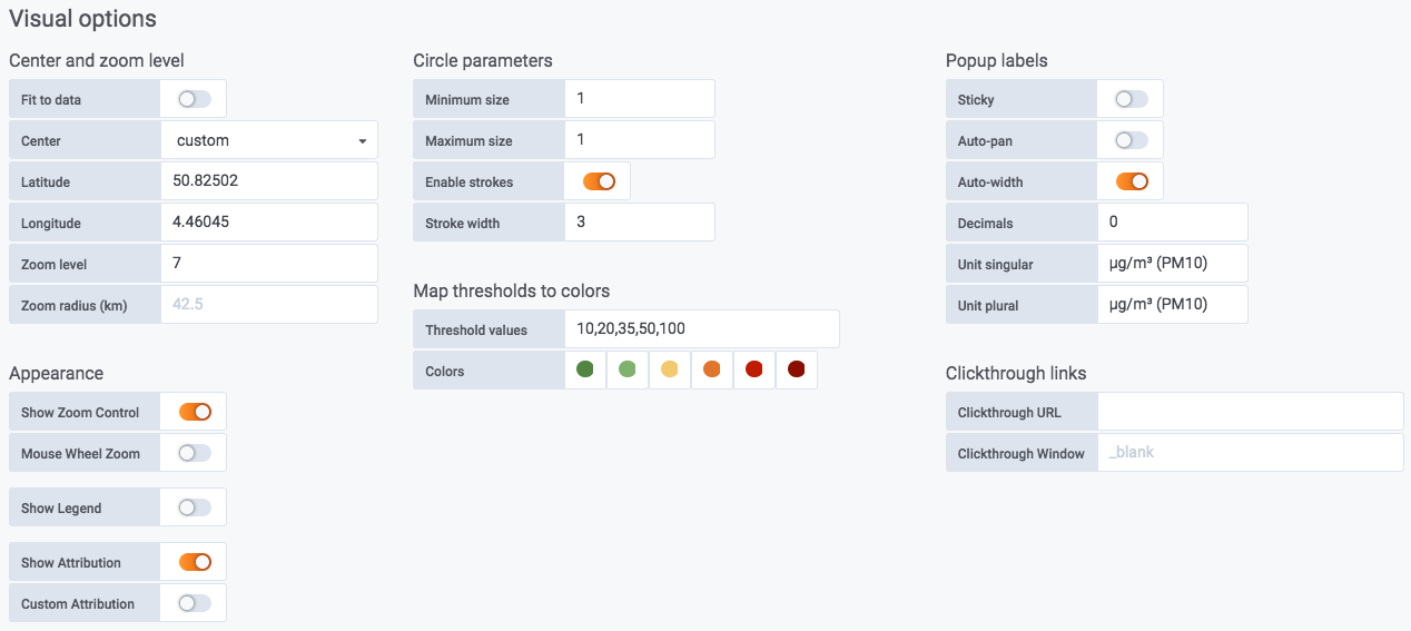
The editor screen has been improved to account for the growing number of settings. While being at it, some controls and their mechanics have been enhanced. The layouts for entering location source, data format, data mapping as well as adjusting visual options have been rearranged. Also, the selector dialogs for data format and mapping as well as map viewport defaults have been improved. -
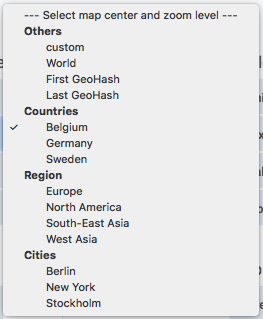
Improve viewport control
- Add map centering to “First geohash” from #156.
- Make the map viewport automatically fit the data within its geographic boundaries using two new control options. Toggling the Fit to data option will choose an optimal center and zoom level for covering the displayed data while the Zoom radius option will optionally override that zoom level by using a fixed zoom radius.
-
Display the legend out-of-band
This feature optionally displays the legend box within a completely different DOM element located anywhere on the same page. This is convenient when rendering many small-sized maps within the same dashboard where the content of the legend is already redundant amongst them and would cover way too much space when rendered into each individual map widget. -
Variable interpolation all the way down
This brings Grafana-style variable interpolation to all panel settings. It will allow you to pull variables from dashboard variables, data point fields and URL request parameters and also override panel control options with URL request parameters.- Query parameters prefixed by
request_are merged into the set of variables interpolation dictionary. - Request parameters prefixed with
panel-optionally override the respective control options.
- Query parameters prefixed by
-
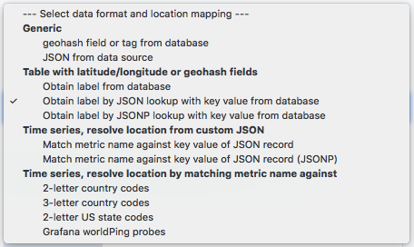
Hybrid
table+json(p)location data
The new mapping optionstable+jsonandtable+jsonpallow retrieving hybrid “table+json(p)” location information from JSON endpoint, even for table data. -
Adjust attribution text
Put an alternative text into the attribution area of the Leaflet map widget. -
Configure circle marker strokes
The new Enable strokes option can be used to turn off strokes on the marker circles, the Stroke width option can be used to adjust the stroke width. -
Verbose notifications about warnings and errors
The internal machinery now yields verbose warnings and error messages into the user interface. Appropriate exception and error handling has been introduced to signal error conditions and warnings to the user which helps tremendously when configuring and operating this plugin. -
Disable automatic width-calculation of popup labels
Toggling the newautoWidthLabelsoption tofalsewill disable automatic width-calculation of popup labels. This helps controlling the popup rendering not to clip when displayed within narrow-sized maps. -
Hide zoom control and attribution label
Toggling the new Show Zoom Control and Show Attribution options can be used to hide the zoom control and attribution text areas. This helps when rendering small-sized maps. -
Improve Kiosk-mode display
In the long term, these options will have to be implemented beyond Panodata Map Panel.- The
ignoreEscapeKeyoption will disable the ESC key to prevent the user leaving Kiosk mode. - The
hideTimepickerNavigationoption will hide the timepicker completely in order to further improve Kiosk mode.
- The
-
Group values of data points from the very same location into a single popup (#27).
Setup
The most recent version of the Panodata Map Panel can be installed side-by-side with the canonical Grafana Worldmap Panel like
# Install most recent version side by side
grafana-cli \
  --pluginUrl https://github.com/panodata/panodata-map-panel/releases/download/0.16.0/panodata-map-panel-0.16.0.zip \
  plugins install panodata-map-panel

# Restart Grafana to activate plugin
systemctl restart grafana-server
Note
Starting with Grafana 7.x, it is mandatory to have plugins signed when running in production mode. However, there is an option to allow loading unsigned plugins in /etc/grafana/grafana.ini within the [plugins] section called
allow_loading_unsigned_plugins = my-plugin-name
which you might be able to use in order to opt-out from this when installing panodata-map-panel.
Development
- Issues · panodata/panodata-map-panel · GitHub (ongoing)
- Developing Grafana Worldmap NG - Benutzerschnittstelle / User interface / API - Hiveeyes (April 2019)
- Giving the Grafana Worldmap Panel some love - Grafana Plugin Development - Grafana Labs Community Forums (May 2019)
- Developing Panodata Map Panel (December 2019)
History
The Panodata Map Panel has been forked from the Grafana Worldmap Panel.
We recently had the chance to dedicate some time to the Grafana Worldmap Panel. After adding some options here and there, some of them coming from the community already [1-4] (specifically we aimed at the drill-down feature here, thanks!), the code has been refactored a bit and finally the user interface has been cleaned up and restructured.
Testimonials
Thanks for putting all this work into the panel. […] great to see the community chipping in. All those features look like good additions. (@daniellee)
We massively appreciate your work and improvements on this plugin. They’re nothing short of transformational in terms of its usefulness. (@svet-b)
This fork has been getting more constant attention for the last year while the core plugin has not moved. (@ryantxu)
Examples
luftdaten.info map for Germany
We are using this to display synthesized address information on a map populated with data coming from luftdatenpumpe through InfluxDB and PostGIS data sources, see also LDI data plane v2.

– Source: luftdaten.info Map Europe
Editor screens
Location source, data format and mapping
Visual options
Details
Data format and mapping flavor
Map viewport defaults (center, zoom level)